


SEO Metadata
Meta Title: TLS vs Mobile SLAM for Scan-to-BIM Accuracy | eLogicTech
Meta Description: TLS delivers sub-centimeter accuracy, mobile SLAM delivers speed. See which scanning method — or which hybrid workflow — actually protects renovation projects from BIM rework.
URL Slug: /blog/tls-vs-mobile-slam-scan-to-bim-accuracy-renovation
Focus Keyword: TLS vs Mobile SLAM Scan-to-BIM
Estimated Read Time: 9 minutes
Primary Keyword: Scan-to-BIM accuracy
Secondary Keywords: TLS vs mobile SLAM, laser scanning for renovation, point cloud to BIM accuracy
Long-Tail Keywords: terrestrial laser scanning vs SLAM for renovation projects, mobile SLAM accuracy for as-built BIM, hybrid scan-to-BIM workflow 2026
Introduction
Every renovation project runs on an assumption nobody says out loud: that the existing conditions model is right. It usually isn’t – not because the scan was bad, but because the wrong scanning method got used for the wrong part of the building. TLS and mobile SLAM solve different problems. Confuse them on a mechanical room or a tight coordination zone, and the model you hand to your design team is the origin story for a change order six months later.
Executive Summary / Key Takeaways
- TLS still holds the accuracy ceiling – single-digit millimeter results after registration, the standard for mechanical rooms and any zone with tight coordination tolerances.
- Mobile SLAM has closed the speed-vs-usability gap dramatically, with leading 2026 platforms capturing at walking pace across thousands of square meters per hour.
- Unconstrained SLAM drifts. Without a registered control network tying it back to survey-grade points, error accumulates across long runs – invisible until coordination fails downstream.
- Noisier SLAM point clouds can add measurable time to BIM modeling, because modelers have to interpret where a surface actually sits instead of tracing a clean edge.
- The dominant 2026 approach on renovation and retrofit work isn’t picking one technology – it’s a hybrid workflow: TLS control network for the skeleton, SLAM for the volume.
Industry Overview
Renovation and retrofit activity has stayed strong heading into 2026, and scan-to-BIM has moved from a specialty service to a default line item on adaptive reuse and existing-building work. The technology conversation has shifted too – it’s no longer “should we scan,” it’s which capture method belongs in which part of the building, and how the two get stitched into one trustworthy model.
Problem Statement
Renovation risk starts before design, not during construction. When existing conditions data doesn’t match what’s actually built, design decisions get made against a fiction – and the gap only becomes visible once trades are on site and the schedule has no slack left to absorb it.
Challenges
- Accuracy vs. speed – TLS is precise but slow to deploy across a full building; SLAM is fast but trades some geometric certainty for that speed.
- Drift over distance – long corridors and multi-floor SLAM runs can bend geometrically if not tied back to fixed control points.
- Noise in modeling – a wall that’s a sharp line in a TLS scan can be a fuzzy band in SLAM data, slowing down accurate BIM authoring.
- Blind trust in spec sheets – published accuracy numbers are lab conditions, not a cluttered occupied building mid-renovation.
Solutions
The fix isn’t choosing a side. It’s zoning the building by tolerance requirement – TLS wherever coordination will be unforgiving, SLAM wherever coverage and speed matter more than the last few millimeters – then registering everything against one control network so the final model reads as a single, trustworthy dataset.
Step-by-Step Process / Methodology
- Establish the control network – static TLS scans at stairwells, elevator cores, and building perimeters to create a drift-free, georeferenced skeleton.
- Deploy mobile SLAM for volume capture – corridors, open floor plates, and general as-built coverage at walking speed.
- Register and tie in – SLAM data anchored to the TLS control points to eliminate drift before any modeling starts.
- Model to LOD requirement – architecture, structure, and MEP built out against the merged point cloud.
- Run 3-stage QA/QC – point cloud verification, dimensional accuracy checks, and discipline-level coordination review before the model goes out the door.
Benefits
- Design decisions made against reality instead of assumption.
- Fewer coordination conflicts surfacing after construction has already started.
- A model your team can actually build from, not just look at.
- Field time and scanning cost matched to what each zone of the building actually requires.
Features / Key Highlights
- Point cloud to BIM – Architecture, MEP, Structural, Civil
- LiDAR & RCP file processing across all major scan formats
- As-built model creation built for renovation and retrofit work
- BIM audits – validating existing models against current scan data
- Multi-discipline coordination with clash detection from day one
Best Practices
- Reserve TLS for mechanical rooms, tight-tolerance zones, and anywhere floor flatness or clash detection will matter.
- Use SLAM for large open areas, corridors, and rapid reconnaissance where sub-centimeter precision isn’t the deciding factor.
- Never let a SLAM run exceed its practical distance from a control point without a re-tie.
- Ask your scanning vendor for real-world field accuracy, not just the manufacturer’s lab-condition number.
Common Mistakes to Avoid
- Scanning a mechanical room or tight MEP corridor with SLAM alone and treating the result as coordination-ready.
- Skipping the TLS control network to save a day on site, then absorbing the drift cost during modeling.
- Modeling directly off raw point cloud without a dimensional accuracy check against the registered data.
- Assuming published SLAM accuracy figures hold up inside a cluttered, occupied building.
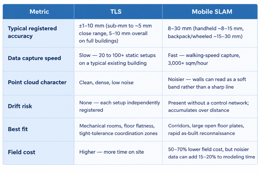
Comparison Table: TLS vs. Mobile SLAM
Statistics & Industry Data
- TLS platforms in 2026 (Faro Focus Premium, Leica RTC360) publish accuracy around ±1mm at 10m under lab conditions; real-world registered accuracy across a full existing building typically lands at ±5-10mm.
- Leading 2026 mobile mapping platforms range from roughly 8mm (Leica BLK2GO handheld) to 15-30mm (GeoSLAM and NavVis backpack systems).
- Mobile capture runs 50-70% cheaper in the field than static TLS, but the noisier data it produces can add roughly 15-20% to downstream BIM modeling time.
- Industry-wide, change orders run 25-30% of project value on renovation work, and cost overruns affect the large majority of construction projects.
Case Study (Illustrative Example)
The following is a generalized, illustrative scenario reflecting a common project type. It does not describe a specific named client.
A regional healthcare system planning a floor-by-floor renovation of an occupied hospital wing needed existing conditions data without shutting down operations. A TLS control network was set at core areas and mechanical rooms overnight, with mobile SLAM covering circulation corridors and patient-area floor plates during low-traffic hours. The merged, registered model gave the design team coordination-ready MEP data in the mechanical rooms and fast, reliable as-built coverage everywhere else – without a full building shutdown for scanning.
Expert Insights / Tips
- Treat scanner spec sheets as a starting point, not a guarantee – verify accuracy against your own registered control points on every project.
- Budget modeling time based on which capture method covered which zone, not a flat rate across the whole building.
- If a renovation touches structural or MEP systems anywhere, that zone gets TLS – no exceptions.
Future Trends
The direction for 2026 and beyond is less about choosing a scanner and more about automation downstream – AI-assisted feature extraction from point cloud data, faster registration between TLS and SLAM datasets, and hybrid capture becoming the default assumption on renovation work rather than a premium option.
Conclusion
TLS and mobile SLAM aren’t competing technologies – they’re two tools solving different parts of the same problem. The projects that avoid renovation change orders aren’t the ones that picked the more expensive scanner. They’re the ones that matched the capture method to the tolerance the zone actually required, then verified everything before design decisions locked in.
Call-to-Action
Have renovation or retrofit work with existing conditions data you’re not fully confident in?
Talk to eLogicTech about a Scan-to-BIM workflow built around your project’s actual tolerance zones.
https://www.elogictech.com/services
Frequently Asked Questions ❓
Is mobile SLAM accurate enough for BIM modeling?
For general as-built coverage, yes. For mechanical rooms, tight clash zones, or anywhere floor flatness matters, TLS remains the standard.
Why not just use TLS everywhere?
Time. Full-building TLS coverage on a large renovation can take days longer than a hybrid approach, without a proportional accuracy gain in low-tolerance areas.
Does SLAM drift ruin the whole model?
Only if it’s left unconstrained. Tied back to a registered TLS control network, drift is corrected before modeling begins.
How is accuracy verified before a model is delivered?
Through structured QA/QC – point cloud verification, dimensional accuracy checks, and discipline-level coordination review.